Address: 3A (From 3A To 7A) REGGIE WAY, BROAD BROOK, CT 06016-1700, USA
What's 06016-1700? 06016-1700 is a ZIP Code 5 Plus 4 number of 3A (From 3A To 7A) REGGIE WAY, BROAD BROOK, CT, USA. Below is detail information.
06016-1700 Basic Information

-
ZIP Code 5 Plus 4:
06016-1700 -
ZIP Code 5:
06016 -
Plus 4?17004-digits that are used to identify a geographic segment within the 5-digit delivery area, such as a city block or a group of apartments or an individual high-volume receiver of mail, or any other unit that could use an extra identifier to aid in efficient mail sorting and delivery. This code is the low end of the range of +4 Codes that pertain to this ZIP Code. ZIP+4 Codes associated with nondelivery areas are composed of valid ZIP sector numbers and "ND" for the ZIP segment number, for example 12345-12ND. Non-deliverable areas are areas to which the USPS does not deliver mail, such as vacant lots and land that borders railroad tracks. Mailers should not match an address identified as a nondelivery area. If you absolutely must have numeric characters in the Plus4Code column, you may treat "ND" values as "00" (zero zero).:
-
Country:
U.S. - United States -
State:
CT - Connecticut -
County:
CountyFIPS: 09003 - Hartford County -
City:
BROAD BROOK -
Street?REGGIE WAYThe official name of a street as assigned by a local governing authority. The Street Name column contains only the street name and does not include directionals (EAST, WEST, etc.) or suffixes (ST, DR, BLVD, etc.). This element may also contain literals, such as PO BOX, GENERAL DELIVERY, USS, PSC, or UNIT. Numeric street names that have numeric components that are four characters (or less) in length at are justified such that the low-order digit of the number is positioned in the fourth position of the street name column. This shift is made so that the numeric street names appear in numeric sequence.:
-
Street Suffix?WAYThe street suffix: For Example: ST = Street RD = Road DR = Drive LN = Lane:
-
Record Type?S: StreetAn alphabetic value that identifies the type of data in the record. Record type codes include the following: G = General delivery H = Highrise F = Firm S = Street P = PO box R = Rural route/highway contract:
Address

- Address Primary Low Number?
A house, rural route, highway contract box, or post office box number; the numeric or alphanumeric component of an address preceding the street name; the low-end address in a range of addresses. Often referred to as house number.: 3A
- Address Primary High Number?
A house, rural route, contract box, or Post Office box number. The numeric or alphanumeric component of an address preceding the street name. The high-end address in a range of addresses. Often referred to as house number.: 7A
- Address Primary Odd / Even Code?
Code that identifies the side or sides of a street for which a given address range is applicable. For street, highrise, firm and multi-carrier records, B = Both sides of a street, E = Even side of a street (even-numbered addresses in the range); O = Odd side of a street (odd-numbered addresses in the range). For general delivery, post office box, and rural route/highway contract records, this code will always be "B" (both).: Both of Odd and Even
- Primary Range: 3A, 3B, 3C, 3D, 3E, 3F, 3G, 3H, 3I, 3J, 3K, 3L, 3M, 3N, 3O, 3P, 3Q, 3R, 3S, 3T, 3U, 3V, 3W, 3X, 3Y, 3Z, 4A, 4B, 4C, 4D, 4E, 4F, 4G, 4H, 4I, 4J, 4K, 4L, 4M, 4N, 4O, 4P, 4Q, 4R, 4S, 4T, 4U, 4V, 4W, 4X, 4Y, 4Z, 5A, 5B, 5C, 5D, 5E, 5F, 5G, 5H, 5I, 5J, 5K, 5L, 5M, 5N, 5O, 5P, 5Q, 5R, 5S, 5T, 5U, 5V, 5W, 5X, 5Y, 5Z, 6A, 6B, 6C, 6D, 6E, 6F, 6G, 6H, 6I, 6J, 6K, 6L, 6M, 6N, 6O, 6P, 6Q, 6R, 6S, 6T, 6U, 6V, 6W, 6X, 6Y, 6Z, 7A.
Please click the "More Address Examples" to view the whole list.
3A REGGIE WAY, BROAD BROOK, CT 06016-1700
3B REGGIE WAY, BROAD BROOK, CT 06016-1700
3C REGGIE WAY, BROAD BROOK, CT 06016-1700
3D REGGIE WAY, BROAD BROOK, CT 06016-1700
3E REGGIE WAY, BROAD BROOK, CT 06016-1700
3F REGGIE WAY, BROAD BROOK, CT 06016-1700
3G REGGIE WAY, BROAD BROOK, CT 06016-1700
3H REGGIE WAY, BROAD BROOK, CT 06016-1700
3I REGGIE WAY, BROAD BROOK, CT 06016-1700
3J REGGIE WAY, BROAD BROOK, CT 06016-1700
3K REGGIE WAY, BROAD BROOK, CT 06016-1700
3L REGGIE WAY, BROAD BROOK, CT 06016-1700
3M REGGIE WAY, BROAD BROOK, CT 06016-1700
3N REGGIE WAY, BROAD BROOK, CT 06016-1700
3O REGGIE WAY, BROAD BROOK, CT 06016-1700
3P REGGIE WAY, BROAD BROOK, CT 06016-1700
3Q REGGIE WAY, BROAD BROOK, CT 06016-1700
3R REGGIE WAY, BROAD BROOK, CT 06016-1700
3S REGGIE WAY, BROAD BROOK, CT 06016-1700
3T REGGIE WAY, BROAD BROOK, CT 06016-1700
3U REGGIE WAY, BROAD BROOK, CT 06016-1700
3V REGGIE WAY, BROAD BROOK, CT 06016-1700
3W REGGIE WAY, BROAD BROOK, CT 06016-1700
3X REGGIE WAY, BROAD BROOK, CT 06016-1700
3Y REGGIE WAY, BROAD BROOK, CT 06016-1700
3Z REGGIE WAY, BROAD BROOK, CT 06016-1700
4A REGGIE WAY, BROAD BROOK, CT 06016-1700
4B REGGIE WAY, BROAD BROOK, CT 06016-1700
4C REGGIE WAY, BROAD BROOK, CT 06016-1700
4D REGGIE WAY, BROAD BROOK, CT 06016-1700
4E REGGIE WAY, BROAD BROOK, CT 06016-1700
4F REGGIE WAY, BROAD BROOK, CT 06016-1700
4G REGGIE WAY, BROAD BROOK, CT 06016-1700
4H REGGIE WAY, BROAD BROOK, CT 06016-1700
4I REGGIE WAY, BROAD BROOK, CT 06016-1700
4J REGGIE WAY, BROAD BROOK, CT 06016-1700
4K REGGIE WAY, BROAD BROOK, CT 06016-1700
4L REGGIE WAY, BROAD BROOK, CT 06016-1700
4M REGGIE WAY, BROAD BROOK, CT 06016-1700
4N REGGIE WAY, BROAD BROOK, CT 06016-1700
4O REGGIE WAY, BROAD BROOK, CT 06016-1700
4P REGGIE WAY, BROAD BROOK, CT 06016-1700
4Q REGGIE WAY, BROAD BROOK, CT 06016-1700
4R REGGIE WAY, BROAD BROOK, CT 06016-1700
4S REGGIE WAY, BROAD BROOK, CT 06016-1700
4T REGGIE WAY, BROAD BROOK, CT 06016-1700
4U REGGIE WAY, BROAD BROOK, CT 06016-1700
4V REGGIE WAY, BROAD BROOK, CT 06016-1700
4W REGGIE WAY, BROAD BROOK, CT 06016-1700
4X REGGIE WAY, BROAD BROOK, CT 06016-1700
4Y REGGIE WAY, BROAD BROOK, CT 06016-1700
4Z REGGIE WAY, BROAD BROOK, CT 06016-1700
5A REGGIE WAY, BROAD BROOK, CT 06016-1700
5B REGGIE WAY, BROAD BROOK, CT 06016-1700
5C REGGIE WAY, BROAD BROOK, CT 06016-1700
5D REGGIE WAY, BROAD BROOK, CT 06016-1700
5E REGGIE WAY, BROAD BROOK, CT 06016-1700
5F REGGIE WAY, BROAD BROOK, CT 06016-1700
5G REGGIE WAY, BROAD BROOK, CT 06016-1700
5H REGGIE WAY, BROAD BROOK, CT 06016-1700
5I REGGIE WAY, BROAD BROOK, CT 06016-1700
5J REGGIE WAY, BROAD BROOK, CT 06016-1700
5K REGGIE WAY, BROAD BROOK, CT 06016-1700
5L REGGIE WAY, BROAD BROOK, CT 06016-1700
5M REGGIE WAY, BROAD BROOK, CT 06016-1700
5N REGGIE WAY, BROAD BROOK, CT 06016-1700
5O REGGIE WAY, BROAD BROOK, CT 06016-1700
5P REGGIE WAY, BROAD BROOK, CT 06016-1700
5Q REGGIE WAY, BROAD BROOK, CT 06016-1700
5R REGGIE WAY, BROAD BROOK, CT 06016-1700
5S REGGIE WAY, BROAD BROOK, CT 06016-1700
5T REGGIE WAY, BROAD BROOK, CT 06016-1700
5U REGGIE WAY, BROAD BROOK, CT 06016-1700
5V REGGIE WAY, BROAD BROOK, CT 06016-1700
5W REGGIE WAY, BROAD BROOK, CT 06016-1700
5X REGGIE WAY, BROAD BROOK, CT 06016-1700
5Y REGGIE WAY, BROAD BROOK, CT 06016-1700
5Z REGGIE WAY, BROAD BROOK, CT 06016-1700
6A REGGIE WAY, BROAD BROOK, CT 06016-1700
6B REGGIE WAY, BROAD BROOK, CT 06016-1700
6C REGGIE WAY, BROAD BROOK, CT 06016-1700
6D REGGIE WAY, BROAD BROOK, CT 06016-1700
6E REGGIE WAY, BROAD BROOK, CT 06016-1700
6F REGGIE WAY, BROAD BROOK, CT 06016-1700
6G REGGIE WAY, BROAD BROOK, CT 06016-1700
6H REGGIE WAY, BROAD BROOK, CT 06016-1700
6I REGGIE WAY, BROAD BROOK, CT 06016-1700
6J REGGIE WAY, BROAD BROOK, CT 06016-1700
6K REGGIE WAY, BROAD BROOK, CT 06016-1700
6L REGGIE WAY, BROAD BROOK, CT 06016-1700
6M REGGIE WAY, BROAD BROOK, CT 06016-1700
6N REGGIE WAY, BROAD BROOK, CT 06016-1700
6O REGGIE WAY, BROAD BROOK, CT 06016-1700
6P REGGIE WAY, BROAD BROOK, CT 06016-1700
6Q REGGIE WAY, BROAD BROOK, CT 06016-1700
6R REGGIE WAY, BROAD BROOK, CT 06016-1700
6S REGGIE WAY, BROAD BROOK, CT 06016-1700
6T REGGIE WAY, BROAD BROOK, CT 06016-1700
6U REGGIE WAY, BROAD BROOK, CT 06016-1700
6V REGGIE WAY, BROAD BROOK, CT 06016-1700
6W REGGIE WAY, BROAD BROOK, CT 06016-1700
6X REGGIE WAY, BROAD BROOK, CT 06016-1700
6Y REGGIE WAY, BROAD BROOK, CT 06016-1700
6Z REGGIE WAY, BROAD BROOK, CT 06016-1700
7A REGGIE WAY, BROAD BROOK, CT 06016-1700
Address Example
BROAD BROOK CT 06016-1700
UNITED STATES OF AMERICA
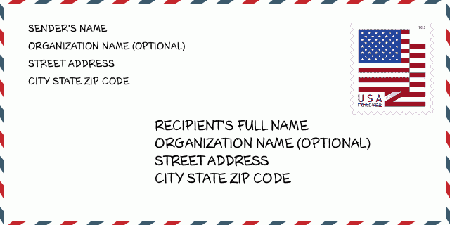
06016-1700 Envelope Example

-
This is an example of U.S envelope. Fill in the sender's information at the top left and the recipient information at the bottom right. The necessary information is sender/recipient's full name, street address, city, state and zip code. The recipient address information has been given for your reference. Generally, If you are not sure of the full 9-digit zip code, you can only fill in the 5-digit zip code to avoid loss of package.
06016-1700 Basic Meaning
-
What does each digit of ZIP Code 06016-1700 stands for? ZIP+4 Code consists of two parts, the first five digits can be located to the post office, and the last four digits can identify a geographic segment within the five-digit delivery area. The 6-7 digits designate sector or several blocks, and the 8-9 digits designate segment or one side of a street.
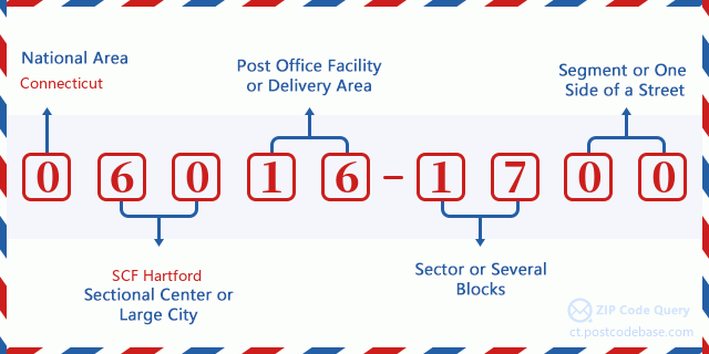

- ·Carrier Route ID?
A 4-digit code assigned to a mail delivery or collection route within a 5-digit ZIP Code. The first character of this identification is alphabetical, and the last three are numeric: Bnnn = PO box Hnnn = Highway contract Rnnn = Rural route Cnnn = City delivery Gnnn = General delivery: R003 (Rural route)
- ·ZIP Add-On Low Sector?
The ZIP Add-On Low Sector and the ZIP Add-On Low Segment together form the ZIP Add-On Low Number. The ZIP Add-On Low Number is the last four positions of a ZIP+4 code; the low-end ZIP add-on in a range of codes; the add-on of the first ZIP+4 code in a consecutive series of ZIP+4 codes assigned to the delivery address. For example, most delivery addresses are assigned a single ZIP+4 code. However, large companies may be given a range of ZIP+4 codes that can be used to route mail to specific departments. A range of ZIP+4 codes can also be assigned to a corresponding range of post office boxes, and each box is mapped, one-to-one, with a ZIP+4 code in the range. A single post office box can also be assigned a range of ZIP+4 codes.: 17
- ·ZIP Add-On Low Segment?
The ZIP Add-On Low Sector and the ZIP Add-On Low Segment together form the ZIP Add-On Low Number. The ZIP Add-On Low Number is the last four positions of a ZIP+4 code; the low-end ZIP add-on in a range of codes; the add-on of the first ZIP+4 code in a consecutive series of ZIP+4 codes assigned to the delivery address. For example, most delivery addresses are assigned a single ZIP+4 code. However, large companies may be given a range of ZIP+4 codes that can be used to route mail to specific departments. A range of ZIP+4 codes can also be assigned to a corresponding range of post office boxes, and each box is mapped, one-to-one, with a ZIP+4 code in the range. A single post office box can also be assigned a range of ZIP+4 codes.: 00
- ·ZIP Add-On High Sector?
The ZIP Add-On High Sector and the ZIP Add-On High Segment together form the ZIP Add-On High Number, which is the high-end ZIP add-on in a range of codes; the add-on of the last ZIP+4 code in a consecutive series of ZIP+4 codes assigned to the delivery address. Most delivery addresses are assigned a single ZIP+4 code; however, large companies may be given a range of ZIP+4 codes that can be used to route mail to specific departments. A range of ZIP+4 codes can also be assigned to a corresponding range of post office boxes, and each box is mapped, one-to-one, with a ZIP+4 code in the range. A single post office box can also be assigned a range of ZIP+4 codes. (See also ZIP Add-On Code.): 17
- ·ZIP Add-On High Segment?
The ZIP Add-On High Sector and the ZIP Add-On High Segment together form the ZIP Add-On High Number, which is the high-end ZIP add-on in a range of codes; the add-on of the last ZIP+4 code in a consecutive series of ZIP+4 codes assigned to the delivery address. Most delivery addresses are assigned a single ZIP+4 code; however, large companies may be given a range of ZIP+4 codes that can be used to route mail to specific departments. A range of ZIP+4 codes can also be assigned to a corresponding range of post office boxes, and each box is mapped, one-to-one, with a ZIP+4 code in the range. A single post office box can also be assigned a range of ZIP+4 codes. (See also ZIP Add-On Code.): 00
- ·ZIP Code Add On: 1700
- ·Range?
The range of +4 codes. Summing the +4 Code and the +4 Range will give you the high end of the range of +4 Codes that pertain to this ZIP Code.: 0
- ·Base Alternate Code?
Code that specifies whether a record is a base (preferred) or alternate record. Base records (represented as "B") can represent a range of addresses or an individual address, such as a firm record, while alternate records (represented as "A") are individual delivery points. Government deliveries will only be listed on alternate records with the appropriate government building indicator (federal, state, or city) set.: Base
- ·Finance Number?
A code assigned to Postal Service facilities (primarily post offices) to collect cost and statistical data and compile revenue and expense data. The state number comprises the first two positions of the finance number.: 080680
- ·Congressional District Number?
A standard value identifying a geographic area within the United States served by a member of the US House of Representatives or Senate. If Army/Air Force (APO) or fleet post office (FPO), this column will be blank. If there is only one member of Congress within a state, the code will be "AL" (at large).: 01
- ·Preferred Last Line City State Key?
An index to the City State file that provides the preferred last-line name for this address range.: V20080
Online Map

This is online map of the address 3A REGGIE WAY, BROAD BROOK. You may use button to move and zoom in / out. The map information is for reference only.
Address: 3A (From 3A To 7A) REGGIE WAY, BROAD BROOK, CT 06016-1700, USA
Comment


Add new comment