地址: 511 (From 511 To 599 Odd) ROUTE 2, PRESTON, CT 06365-8835, USA
06365-8835是什麼 06365-8835是 511 (From 511 To 599 Odd) ROUTE 2, PRESTON, CT, USA的5加4位邮编。下面是详细信息。
06365-8835基本信息

-
郵政編碼5加4:
06365-8835 -
郵政編碼5:
06365 -
加4?88354-digits that are used to identify a geographic segment within the 5-digit delivery area, such as a city block or a group of apartments or an individual high-volume receiver of mail, or any other unit that could use an extra identifier to aid in efficient mail sorting and delivery. This code is the low end of the range of +4 Codes that pertain to this ZIP Code. ZIP+4 Codes associated with nondelivery areas are composed of valid ZIP sector numbers and "ND" for the ZIP segment number, for example 12345-12ND. Non-deliverable areas are areas to which the USPS does not deliver mail, such as vacant lots and land that borders railroad tracks. Mailers should not match an address identified as a nondelivery area. If you absolutely must have numeric characters in the Plus4Code column, you may treat "ND" values as "00" (zero zero).:
-
國家:
U.S. - 美國 -
州:
CT - 康涅狄格 -
區縣:
CountyFIPS: 09011 - New London County -
城市:
PRESTON -
街道?ROUTE 2The official name of a street as assigned by a local governing authority. The Street Name column contains only the street name and does not include directionals (EAST, WEST, etc.) or suffixes (ST, DR, BLVD, etc.). This element may also contain literals, such as PO BOX, GENERAL DELIVERY, USS, PSC, or UNIT. Numeric street names that have numeric components that are four characters (or less) in length at are justified such that the low-order digit of the number is positioned in the fourth position of the street name column. This shift is made so that the numeric street names appear in numeric sequence.:
-
記錄類型?S: 街道An alphabetic value that identifies the type of data in the record. Record type codes include the following: G = General delivery H = Highrise F = Firm S = Street P = PO box R = Rural route/highway contract:
地址

- 主要地址地位數字?
A house, rural route, highway contract box, or post office box number; the numeric or alphanumeric component of an address preceding the street name; the low-end address in a range of addresses. Often referred to as house number.: 511
- 主要地址高位數字?
A house, rural route, contract box, or Post Office box number. The numeric or alphanumeric component of an address preceding the street name. The high-end address in a range of addresses. Often referred to as house number.: 599
- 主要地址奇/偶碼?
Code that identifies the side or sides of a street for which a given address range is applicable. For street, highrise, firm and multi-carrier records, B = Both sides of a street, E = Even side of a street (even-numbered addresses in the range); O = Odd side of a street (odd-numbered addresses in the range). For general delivery, post office box, and rural route/highway contract records, this code will always be "B" (both).: Odd
- 主要範圍: 511, 513, 515, 517, 519, 521, 523, 525, 527, 529, 531, 533, 535, 537, 539, 541, 543, 545, 547, 549, 551, 553, 555, 557, 559, 561, 563, 565, 567, 569, 571, 573, 575, 577, 579, 581, 583, 585, 587, 589, 591, 593, 595, 597, 599.
請單擊"更多地址示例"查看整個列表。
511 ROUTE 2, PRESTON, CT 06365-8835
513 ROUTE 2, PRESTON, CT 06365-8835
515 ROUTE 2, PRESTON, CT 06365-8835
517 ROUTE 2, PRESTON, CT 06365-8835
519 ROUTE 2, PRESTON, CT 06365-8835
521 ROUTE 2, PRESTON, CT 06365-8835
523 ROUTE 2, PRESTON, CT 06365-8835
525 ROUTE 2, PRESTON, CT 06365-8835
527 ROUTE 2, PRESTON, CT 06365-8835
529 ROUTE 2, PRESTON, CT 06365-8835
531 ROUTE 2, PRESTON, CT 06365-8835
533 ROUTE 2, PRESTON, CT 06365-8835
535 ROUTE 2, PRESTON, CT 06365-8835
537 ROUTE 2, PRESTON, CT 06365-8835
539 ROUTE 2, PRESTON, CT 06365-8835
541 ROUTE 2, PRESTON, CT 06365-8835
543 ROUTE 2, PRESTON, CT 06365-8835
545 ROUTE 2, PRESTON, CT 06365-8835
547 ROUTE 2, PRESTON, CT 06365-8835
549 ROUTE 2, PRESTON, CT 06365-8835
551 ROUTE 2, PRESTON, CT 06365-8835
553 ROUTE 2, PRESTON, CT 06365-8835
555 ROUTE 2, PRESTON, CT 06365-8835
557 ROUTE 2, PRESTON, CT 06365-8835
559 ROUTE 2, PRESTON, CT 06365-8835
561 ROUTE 2, PRESTON, CT 06365-8835
563 ROUTE 2, PRESTON, CT 06365-8835
565 ROUTE 2, PRESTON, CT 06365-8835
567 ROUTE 2, PRESTON, CT 06365-8835
569 ROUTE 2, PRESTON, CT 06365-8835
571 ROUTE 2, PRESTON, CT 06365-8835
573 ROUTE 2, PRESTON, CT 06365-8835
575 ROUTE 2, PRESTON, CT 06365-8835
577 ROUTE 2, PRESTON, CT 06365-8835
579 ROUTE 2, PRESTON, CT 06365-8835
581 ROUTE 2, PRESTON, CT 06365-8835
583 ROUTE 2, PRESTON, CT 06365-8835
585 ROUTE 2, PRESTON, CT 06365-8835
587 ROUTE 2, PRESTON, CT 06365-8835
589 ROUTE 2, PRESTON, CT 06365-8835
591 ROUTE 2, PRESTON, CT 06365-8835
593 ROUTE 2, PRESTON, CT 06365-8835
595 ROUTE 2, PRESTON, CT 06365-8835
597 ROUTE 2, PRESTON, CT 06365-8835
599 ROUTE 2, PRESTON, CT 06365-8835
地址範例
PRESTON CT 06365-8835
UNITED STATES OF AMERICA
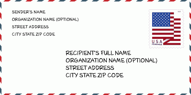
06365-8835信封例子

-
這是美國信封例子。在左上角填寫發件人信息,右下角填寫收件人信息。必須要填寫的信息有發件人和收件人的姓名、街道地址、城市、州還有郵政編碼。收件人的地址示例僅供參考。通常來說,如果你不確定九位郵件,你可以僅僅填寫五位郵編,以避免郵件丟失。
06365-8835基本含義
-
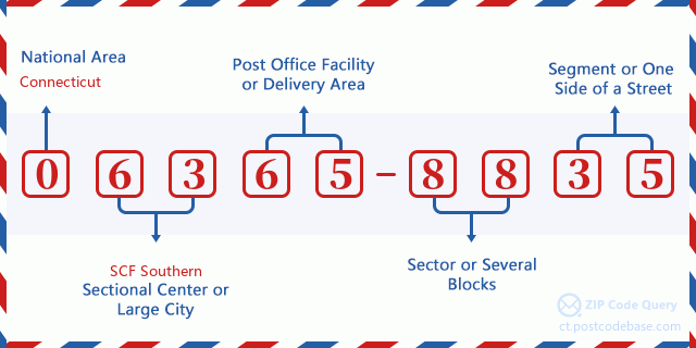
郵政編碼 06365-8835 的每個數字代表什麼?ZIP+4 Code由兩部分組成,前五位數字可以定位到郵局,後四位數字可以確定五位數字遞送區域內的一個地理區段。 6-7位數字指定區域或幾個街區,8-9位數字指定區段或街道的一側。

- ·運輸路線ID?
A 4-digit code assigned to a mail delivery or collection route within a 5-digit ZIP Code. The first character of this identification is alphabetical, and the last three are numeric: Bnnn = PO box Hnnn = Highway contract Rnnn = Rural route Cnnn = City delivery Gnnn = General delivery: R001 (農村路線)
- ·郵遞附加低部?
The ZIP Add-On Low Sector and the ZIP Add-On Low Segment together form the ZIP Add-On Low Number. The ZIP Add-On Low Number is the last four positions of a ZIP+4 code; the low-end ZIP add-on in a range of codes; the add-on of the first ZIP+4 code in a consecutive series of ZIP+4 codes assigned to the delivery address. For example, most delivery addresses are assigned a single ZIP+4 code. However, large companies may be given a range of ZIP+4 codes that can be used to route mail to specific departments. A range of ZIP+4 codes can also be assigned to a corresponding range of post office boxes, and each box is mapped, one-to-one, with a ZIP+4 code in the range. A single post office box can also be assigned a range of ZIP+4 codes.: 88
- ·郵遞附加低段?
The ZIP Add-On Low Sector and the ZIP Add-On Low Segment together form the ZIP Add-On Low Number. The ZIP Add-On Low Number is the last four positions of a ZIP+4 code; the low-end ZIP add-on in a range of codes; the add-on of the first ZIP+4 code in a consecutive series of ZIP+4 codes assigned to the delivery address. For example, most delivery addresses are assigned a single ZIP+4 code. However, large companies may be given a range of ZIP+4 codes that can be used to route mail to specific departments. A range of ZIP+4 codes can also be assigned to a corresponding range of post office boxes, and each box is mapped, one-to-one, with a ZIP+4 code in the range. A single post office box can also be assigned a range of ZIP+4 codes.: 35
- ·郵遞附加高部?
The ZIP Add-On High Sector and the ZIP Add-On High Segment together form the ZIP Add-On High Number, which is the high-end ZIP add-on in a range of codes; the add-on of the last ZIP+4 code in a consecutive series of ZIP+4 codes assigned to the delivery address. Most delivery addresses are assigned a single ZIP+4 code; however, large companies may be given a range of ZIP+4 codes that can be used to route mail to specific departments. A range of ZIP+4 codes can also be assigned to a corresponding range of post office boxes, and each box is mapped, one-to-one, with a ZIP+4 code in the range. A single post office box can also be assigned a range of ZIP+4 codes. (See also ZIP Add-On Code.): 88
- ·郵遞附加高段?
The ZIP Add-On High Sector and the ZIP Add-On High Segment together form the ZIP Add-On High Number, which is the high-end ZIP add-on in a range of codes; the add-on of the last ZIP+4 code in a consecutive series of ZIP+4 codes assigned to the delivery address. Most delivery addresses are assigned a single ZIP+4 code; however, large companies may be given a range of ZIP+4 codes that can be used to route mail to specific departments. A range of ZIP+4 codes can also be assigned to a corresponding range of post office boxes, and each box is mapped, one-to-one, with a ZIP+4 code in the range. A single post office box can also be assigned a range of ZIP+4 codes. (See also ZIP Add-On Code.): 35
- ·郵政編碼附加: 8835
- ·範圍?
The range of +4 codes. Summing the +4 Code and the +4 Range will give you the high end of the range of +4 Codes that pertain to this ZIP Code.: 0
- ·基本替代代碼?
Code that specifies whether a record is a base (preferred) or alternate record. Base records (represented as "B") can represent a range of addresses or an individual address, such as a firm record, while alternate records (represented as "A") are individual delivery points. Government deliveries will only be listed on alternate records with the appropriate government building indicator (federal, state, or city) set.: 基本
- ·財務數字?
A code assigned to Postal Service facilities (primarily post offices) to collect cost and statistical data and compile revenue and expense data. The state number comprises the first two positions of the finance number.: 085440
- ·國會分區號碼?
A standard value identifying a geographic area within the United States served by a member of the US House of Representatives or Senate. If Army/Air Force (APO) or fleet post office (FPO), this column will be blank. If there is only one member of Congress within a state, the code will be "AL" (at large).: 02
- ·最後行市州代碼?
An index to the City State file that provides the preferred last-line name for this address range.: V27415
在線地圖

这是地址511 ROUTE 2 PRESTON匹配的在线电子地图。您可以使用图中按钮来移动、缩放。该地图信息仅供参考。
地址: 511 (From 511 To 599 Odd) ROUTE 2, PRESTON, CT 06365-8835, USA
回應


發表新回應